Tuesday, September 28, 2010

Plotting Large Image Files

I recently received a 100 MB raster image file from a client, and needed to use it as a background image in a bathymetric map of a reservoir. The image was a very high resolution TIFF file, depicting the bottom of the reservoir in great detail, which the client needed to see in his maps. It looked great in model space, on the layout tab, and even showed up in a plot preview, but when I tried to plot it to a PDF, the image was absent from the final plot.


Obviously, when plotting a lot of software and hardware variables come into play. I found a couple of solutions that helped in my situations; perhaps they will help you in similar situations.

For the complete tutorial, (and many others) follow this link...


Share/Save/Bookmark

Tuesday, September 21, 2010

Maps on Clothing

Everyone who knows me knows that I am a map nerd. I surround myself with maps, even on everyday objects. The coffee cup I've used for over 23 years sports a map of the London Underground, and my favorite shirt features coastline patterns from nautical maps.

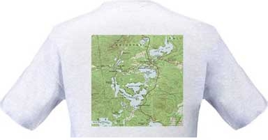
I thought I would list a few other sources for maps on clothing, starting with my friend Autumn's TopoTees; skillfully printed T-shirts featuring images of some of the lakes in the Adirondacks from vintage USGS quadrangles. If you order one, please tell them: "Russell sent me!"


There are many different sources for maps on clothing. You can also get maps on shoes, jackets, even boxer shorts, but the TopoTees are more my style...

Please send me links to your favorite items featuring maps.


Share/Save/Bookmark